
Cathlamet topographic map
Interactive map
Click on the map to display elevation.
About this map
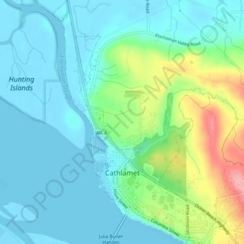
Name: Cathlamet topographic map, elevation, terrain.
Location: Cathlamet, Wahkiakum County, Washington, United States (46.19428 -123.39584 46.22468 -123.37152)
Average elevation: 30 m
Minimum elevation: -2 m
Maximum elevation: 127 m
Other topographic maps
Click on a map to view its topography, its elevation and its terrain.