
Minnetonka topographic map
Interactive map
Click on the map to display elevation.
About this map
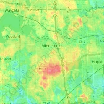
Name: Minnetonka topographic map, elevation, terrain.
Location: Minnetonka, Hennepin County, Minnesota, United States (44.89140 -93.52334 44.97884 -93.39896)
Average elevation: 290 m
Minimum elevation: 260 m
Maximum elevation: 341 m
Other topographic maps
Click on a map to view its topography, its elevation and its terrain.
Grays Bay
United States > Minnesota > Hennepin County > Minnetonka
Grays Bay, Minnetonka, Hennepin County, Minnesota, 55391, United States
Average elevation: 288 m
Oak Knoll
United States > Minnesota > Hennepin County > Minnetonka
Oak Knoll, Minnetonka, Hennepin County, Minnesota, 55305, United States
Average elevation: 288 m