
Make a donation
Gear up for your next adventure:
As an Amazon Associate, this site earns from qualifying purchases at no extra cost to you.
Žižkov topographic map
Click on the map to display elevation.
Make a donation
Gear up for your next adventure:
As an Amazon Associate, this site earns from qualifying purchases at no extra cost to you.
About this map
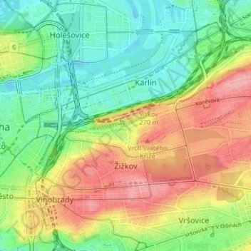
Name: Žižkov topographic map, elevation, terrain.
Location: Žižkov, Prague, Czechia (50.07761 14.43806 50.09785 14.50332)
Average elevation: 232 m
Minimum elevation: 181 m
Maximum elevation: 287 m
Make a donation
Gear up for your next adventure:
As an Amazon Associate, this site earns from qualifying purchases at no extra cost to you.
Other topographic maps
Click on a map to view its topography, its elevation and its terrain.
Letná Park
Letná Park (Czech: Letenské sady) is a large park on Letná hill, built on a plateau above steep embankments along the Vltava River in Prague, Czech Republic. Letná's elevation and location afford commanding views of the Prague Old Town (Staré Město).
Average elevation: 214 m