
Make a donation
Gear up for your next adventure:
As an Amazon Associate, this site earns from qualifying purchases at no extra cost to you.
Guardamar del Segura topographic map
Click on the map to display elevation.
Make a donation
Gear up for your next adventure:
As an Amazon Associate, this site earns from qualifying purchases at no extra cost to you.
About this map
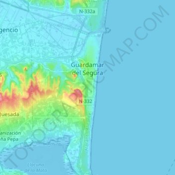
Name: Guardamar del Segura topographic map, elevation, terrain.
Average elevation: 9 m
Minimum elevation: -5 m
Maximum elevation: 105 m
Make a donation
Gear up for your next adventure:
As an Amazon Associate, this site earns from qualifying purchases at no extra cost to you.
Other topographic maps
Click on a map to view its topography, its elevation and its terrain.
Playa Flamenca I
Spain > Valencian Community > el Baix Segura / La Vega Baja del Segura > Orihuela > Urbanización La Zenia
Average elevation: 25 m
Cabo Roig
Spain > Valencian Community > el Baix Segura / La Vega Baja del Segura > Orihuela
Average elevation: 9 m
Dehesa de Campoamor
Spain > Valencian Community > el Baix Segura / La Vega Baja del Segura > Orihuela
Average elevation: 28 m
Urbanización Doña Pepa
Spain > Valencian Community > el Baix Segura / La Vega Baja del Segura > Rojales
Average elevation: 24 m
Make a donation
Gear up for your next adventure:
As an Amazon Associate, this site earns from qualifying purchases at no extra cost to you.
Torre de la Horadada
Spain > Valencian Community > el Baix Segura / La Vega Baja del Segura > Pilar de la Horadada
Average elevation: 5 m
Villa Martín
Spain > Valencian Community > el Baix Segura / La Vega Baja del Segura > Orihuela > Villa Martín
Average elevation: 74 m