
Basin topographic map
Interactive map
Click on the map to display elevation.
Basin
Basin, in Jefferson County, is part of the Helena Micropolitan Statistical Area. It lies at an elevation of 5,364 feet (1,635 m) above sea level along Interstate 15 about 30 miles (48 km) by road north of Butte and 38 miles (61 km) south of Helena in a narrow canyon. The community is largely surrounded by the Beaverhead-Deerlodge National Forest. Basin Creek flows south through the center of Basin to its confluence with a larger stream, the Boulder River, which flows east along the south side of Basin. No paved roads except the interstate highway, which runs along the river canyon, connect Basin to other towns. About 10 miles (16 km) upstream on Basin Creek lies the Continental Divide. According to the United States Census Bureau, the CDP has a total area of 12.7 square miles (33.0 km2), all land.
About this map
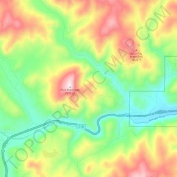
Name: Basin topographic map, elevation, terrain.
Location: Basin, Jefferson County, Montana, 59631, United States (46.24418 -112.34150 46.31794 -112.24101)
Average elevation: 1,892 m
Minimum elevation: 1,603 m
Maximum elevation: 2,304 m
Other topographic maps
Click on a map to view its topography, its elevation and its terrain.