
Municipal Unit of Nafpaktos topographic map
Interactive map
Click on the map to display elevation.
About this map
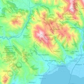
Name: Municipal Unit of Nafpaktos topographic map, elevation, terrain.
Average elevation: 421 m
Minimum elevation: -6 m
Maximum elevation: 1,465 m
Other topographic maps
Click on a map to view its topography, its elevation and its terrain.
Nafpaktos
Greece > Peloponnese, Western Greece and the Ionian > Municipal Unit of Nafpaktos > Nafpaktos
Nafpaktos, Municipal Unit of Nafpaktos, Municipality of Nafpaktia, Aetolia-Acarnania Regional Unit, Western Greece, Peloponnese, Western Greece and the Ionian, 30300, Greece
Average elevation: 130 m