
Thank you for supporting this site ❤️
Make a donation
Make a donation
Gear up for your next adventure:
As an Amazon Associate, this site earns from qualifying purchases at no extra cost to you.
Deerness topographic map
Click on the map to display elevation.
Thank you for supporting this site ❤️
Make a donation
Make a donation
Gear up for your next adventure:
As an Amazon Associate, this site earns from qualifying purchases at no extra cost to you.
About this map
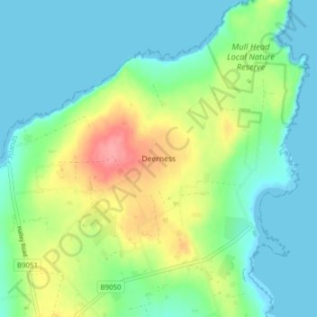
Name: Deerness topographic map, elevation, terrain.
Location: Deerness, Orkney Islands, Scotland, KW17 2QH, United Kingdom (58.93168 -2.76003 58.97168 -2.72003)
Average elevation: 26 m
Minimum elevation: -1 m
Maximum elevation: 86 m
Scotland trails, hiking, mountain biking, running and outdoor activities
Thank you for supporting this site ❤️
Make a donation
Make a donation
Gear up for your next adventure:
As an Amazon Associate, this site earns from qualifying purchases at no extra cost to you.