
Vasant Vihar topographic map
Interactive map
Click on the map to display elevation.
About this map
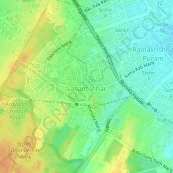
Name: Vasant Vihar topographic map, elevation, terrain.
Average elevation: 244 m
Minimum elevation: 228 m
Maximum elevation: 264 m
Other topographic maps
Click on a map to view its topography, its elevation and its terrain.
Ramakrishna Puram
Ramakrishna Puram, Vasant Vihar Tehsil, New Delhi, Delhi, India
Average elevation: 235 m
Vasant Kunj
Vasant Kunj, Vasant Vihar Tehsil, New Delhi, Delhi, India
Average elevation: 261 m
Central Ridge Reserve Forest
Central Ridge Reserve Forest, Delhi Cantonment, New Delhi, Delhi, India
Average elevation: 235 m
Chanakyapuri
Chanakyapuri, Chanakya Puri Tehsil, New Delhi, Delhi, 110021, India
Average elevation: 228 m
Lodhi Gardens
Lodhi Gardens, Rabindra Nagar, New Delhi, Chanakya Puri Tehsil, Delhi, India
Average elevation: 214 m