
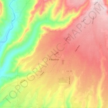
Paradise topographic map
Interactive map
Click on the map to display elevation.
About this map
Name: Paradise topographic map, elevation, terrain.
Location: Paradise, Butte County, California, 95969, United States (39.72536 -121.65565 39.80154 -121.56445)
Average elevation: 464 m
Minimum elevation: 139 m
Maximum elevation: 726 m
The town is spread out on a wide ridge between deep canyons formed by the west branch of the Feather River to the east and Butte Creek to the west. The Paradise area extends northward to include the unincorporated town of Magalia, as well as Stirling City, eleven miles (18 km) north. Elevation of the area where the town is located is 1,778 feet (542 m). The town itself is approximately eight miles (13 km) east of the city of Chico, and ten miles (16 km) north of the Oroville area.
Other topographic maps
Click on a map to view its topography, its elevation and its terrain.
Lake Oroville
United States > California > Butte County
Lake Oroville, Butte County, California, United States
Average elevation: 392 m
Paradise Dam
United States > California > Butte County
Paradise Dam, Butte County, California, United States
Average elevation: 789 m
North Fork Feather River
United States > California > Butte County
North Fork Feather River, Butte County, CAL Fire Northern Region, California, United States
Average elevation: 714 m
Merrimac
United States > California > Butte County
Merrimac, Butte County, CAL Fire Northern Region, California, United States
Average elevation: 1,191 m
Paradise Pines
United States > California > Butte County
Paradise Pines, Butte County, CAL Fire Northern Region, California, United States
Average elevation: 724 m
Peachton
United States > California > Butte County
Peachton, Butte County, CAL Fire Northern Region, California, 95948, United States
Average elevation: 30 m
Pulga
United States > California > Butte County > Pulga
Pulga, Butte County, California, 95980, United States
Average elevation: 750 m
Chico
United States > California > Butte County
Chico, Butte County, California, United States
Average elevation: 94 m
Big Bend
United States > California > Butte County
Big Bend, Butte County, CAL Fire Northern Region, California, United States
Average elevation: 574 m
Oroville Dam
United States > California > Butte County
Oroville Dam, Butte County, California, United States
Average elevation: 226 m