
Make a donation
Gear up for your next adventure:
As an Amazon Associate, this site earns from qualifying purchases at no extra cost to you.
Houma topographic map
Click on the map to display elevation.
Make a donation
Gear up for your next adventure:
As an Amazon Associate, this site earns from qualifying purchases at no extra cost to you.
Houma
Houma is located at 29°35′15″N 90°42′58″W / 29.58750°N 90.71611°W / 29.58750; -90.71611 (29.587614, -90.716108) and has an elevation of 10 feet (3.0 m) above sea level. According to the United States Census Bureau, the city has a total area of 14.2 square miles (37 km2), of which 14.0 square miles (36 km2) is land and 0.2 square miles (0.52 km2) (0.92%) is water.
Make a donation
Gear up for your next adventure:
As an Amazon Associate, this site earns from qualifying purchases at no extra cost to you.
About this map
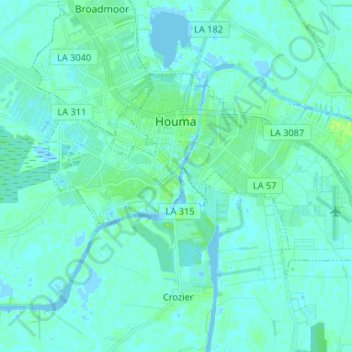
Name: Houma topographic map, elevation, terrain.
Location: Houma, Terrebonne Parish, Louisiana, United States (29.54493 -90.76703 29.61142 -90.63588)
Average elevation: 3 m
Minimum elevation: -2 m
Maximum elevation: 11 m
Make a donation
Gear up for your next adventure:
As an Amazon Associate, this site earns from qualifying purchases at no extra cost to you.
Other topographic maps
Click on a map to view its topography, its elevation and its terrain.
Make a donation
Gear up for your next adventure:
As an Amazon Associate, this site earns from qualifying purchases at no extra cost to you.