
Mount Parnitha National Park topographic map
Interactive map
Click on the map to display elevation.
About this map
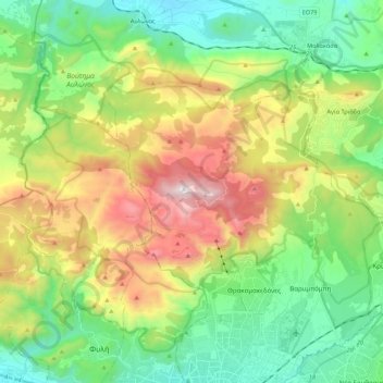
Name: Mount Parnitha National Park topographic map, elevation, terrain.
Average elevation: 543 m
Minimum elevation: 86 m
Maximum elevation: 1,397 m
Other topographic maps
Click on a map to view its topography, its elevation and its terrain.
Rafina
Greece > Attica > Regional Unit of East Attica > Rafina Municipal Unit
Rafina, Rafina Municipal Unit, Municipality of Rafina - Pikermi, Regional Unit of East Attica, Attica, 190 09, Greece
Average elevation: 44 m
Astypalaia
Greece > Attica > Regional Unit of East Attica > Anavissos Municipal Unit
Astypalaia, Anavissos Municipal Unit, Municipality of Saronikos, Regional Unit of East Attica, Attica, 190 13, Greece
Average elevation: 10 m
Ανάβυσσος
Greece > Attica > Regional Unit of East Attica > Anavissos Municipal Unit
Ανάβυσσος, Anavissos Municipal Unit, Municipality of Saronikos, Regional Unit of East Attica, Attica, 190 13, Greece
Average elevation: 91 m
Koropi
Greece > Attica > Regional Unit of East Attica
Koropi, Municipality of Kropia, Regional Unit of East Attica, Attica, 194 00, Greece
Average elevation: 148 m
Nea Makri Municipal Unit
Greece > Attica > Regional Unit of East Attica
Nea Makri Municipal Unit, Municipality of Marathonas, Regional Unit of East Attica, Attica, 190 05, Greece
Average elevation: 217 m
Christoupoli
Greece > Attica > Regional Unit of East Attica > Spata-Loutsa Municipal Unit
Christoupoli, Spata-Loutsa Community, Spata-Loutsa Municipal Unit, Municipality of Spata - Artemida, Regional Unit of East Attica, Attica, 190 04, Greece
Average elevation: 122 m
Limenas Markopoulou
Greece > Attica > Regional Unit of East Attica
Limenas Markopoulou, Municipality of Markopoulo Mesogaias, Regional Unit of East Attica, Attica, 190 23, Greece
Average elevation: 93 m
Municipal Unit of Voula
Greece > Attica > Regional Unit of East Attica
Municipal Unit of Voula, Municipality of Vari - Voula - Vouliagmeni, Regional Unit of East Attica, Attica, 166 73, Greece
Average elevation: 57 m
Glyka Nera Municipal Unit
Greece > Attica > Regional Unit of East Attica
Glyka Nera Municipal Unit, Municipality of Paiania, Regional Unit of East Attica, Attica, 153 54, Greece
Average elevation: 309 m
Artemida
Greece > Attica > Regional Unit of East Attica > Artemida Municipal Unit
Artemida, Artemida Municipal Unit, Municipality of Spata - Artemida, Regional Unit of East Attica, Attica, 190 16, Greece
Average elevation: 38 m
Municipality of Lavreotiki
Greece > Attica > Regional Unit of East Attica
Municipality of Lavreotiki, Regional Unit of East Attica, Attica, Greece
Average elevation: 80 m
Gerakas Municipal Unit
Greece > Attica > Regional Unit of East Attica
Gerakas Municipal Unit, Municipality of Pallini, Regional Unit of East Attica, Attica, 153 44, Greece
Average elevation: 259 m
Vouliagmeni Municipal Unit
Greece > Attica > Regional Unit of East Attica
Vouliagmeni Municipal Unit, Municipality of Vari - Voula - Vouliagmeni, Regional Unit of East Attica, Attica, 166 71, Greece
Average elevation: 20 m
Pikermi Municipal Unit
Greece > Attica > Regional Unit of East Attica > Pikermi Municipal Unit
Pikermi Municipal Unit, Municipality of Rafina - Pikermi, Regional Unit of East Attica, Attica, Greece
Average elevation: 227 m
Anavissos Municipal Unit
Greece > Attica > Regional Unit of East Attica
Anavissos Municipal Unit, Municipality of Saronikos, Regional Unit of East Attica, Attica, Greece
Average elevation: 60 m
Marathon
Greece > Attica > Regional Unit of East Attica
Marathon, Municipality of Marathonas, Regional Unit of East Attica, Attica, 190 07, Greece
Average elevation: 146 m