
Make a donation
Gear up for your next adventure:
As an Amazon Associate, this site earns from qualifying purchases at no extra cost to you.
Vineland topographic map
Click on the map to display elevation.
Make a donation
Gear up for your next adventure:
As an Amazon Associate, this site earns from qualifying purchases at no extra cost to you.
About this map
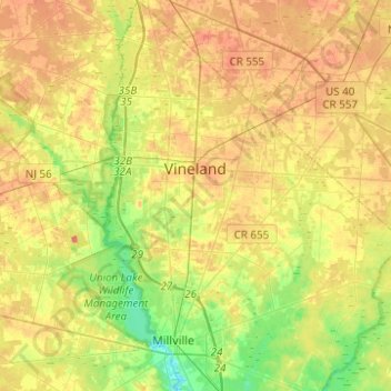
Name: Vineland topographic map, elevation, terrain.
Location: Vineland, Cumberland County, New Jersey, United States (39.37772 -75.08660 39.56860 -74.89663)
Average elevation: 25 m
Minimum elevation: -1 m
Maximum elevation: 47 m
Make a donation
Gear up for your next adventure:
As an Amazon Associate, this site earns from qualifying purchases at no extra cost to you.
Other topographic maps
Click on a map to view its topography, its elevation and its terrain.
West Creek
United States > New Jersey > Cumberland County > Maurice River Township
Average elevation: 5 m
Willis Corner
United States > New Jersey > Cumberland County > Stow Creek Township
Average elevation: 11 m
Greenwich
United States > New Jersey > Cumberland County > Greenwich Township > Greenwich
Average elevation: 2 m
Make a donation
Gear up for your next adventure:
As an Amazon Associate, this site earns from qualifying purchases at no extra cost to you.