
Lenzie topographic map
Interactive map
Click on the map to display elevation.
About this map
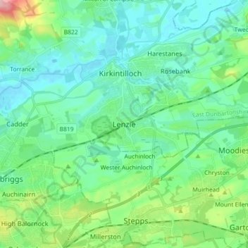
Name: Lenzie topographic map, elevation, terrain.
Location: Lenzie, East Dunbartonshire, Scotland, G66 5ER, United Kingdom (55.88196 -4.19282 55.96196 -4.11282)
Average elevation: 68 m
Minimum elevation: 33 m
Maximum elevation: 197 m
East Dunbartonshire trails, hiking, mountain biking, running and outdoor activities
Other topographic maps
Click on a map to view its topography, its elevation and its terrain.
Craigmaddie Reservoir
United Kingdom > Scotland > East Dunbartonshire > Milngavie
Average elevation: 97 m