
Municipality of Kalavryta topographic map
Interactive map
Click on the map to display elevation.
About this map
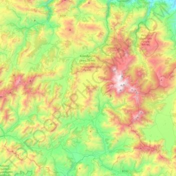
Name: Municipality of Kalavryta topographic map, elevation, terrain.
Average elevation: 975 m
Minimum elevation: 120 m
Maximum elevation: 2,316 m
Other topographic maps
Click on a map to view its topography, its elevation and its terrain.
Kastria
Greece > Peloponnese, Western Greece and the Ionian > Municipality of Kalavryta > Kastria
Average elevation: 976 m