
Monterrey topographic map
Interactive map
Click on the map to display elevation.
Monterrey
The region corresponds to a folded structural system whose height and shape is caused by the action of tectonic forces on a set of sedimentary rocks of different composition, which are being affected by denudative phenomena. The mountains are located on the western side of the municipality. Due to tectonic activity of the region, the topography can be abrupt, with slopes greater than 45%. Heights of the mountains range from 800 to 2000 MASL also due to unstable tectonics. Monterrey is home to many Monoclinal ridges corresponding to elongated forms in the form of asymmetric blades that protrude due to their height within the mountainous system. They are escarpments whose structural slopes are regular due to the uniformity and hardness of the rocks that conform it, corresponding to elongated blades of high slope and edges associated with sandstone.
About this map
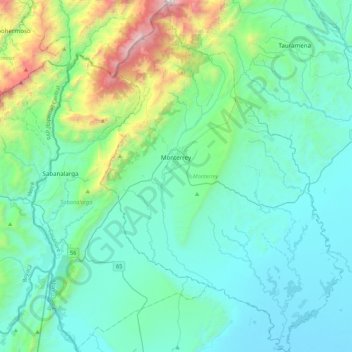
Name: Monterrey topographic map, elevation, terrain.
Location: Monterrey, Casanare, RAP Llanos, 855010, Colombia (4.63761 -72.98975 5.06875 -72.69082)
Average elevation: 521 m
Minimum elevation: 187 m
Maximum elevation: 2,440 m
Other topographic maps
Click on a map to view its topography, its elevation and its terrain.