
Eastsound topographic map
Interactive map
Click on the map to display elevation.
About this map
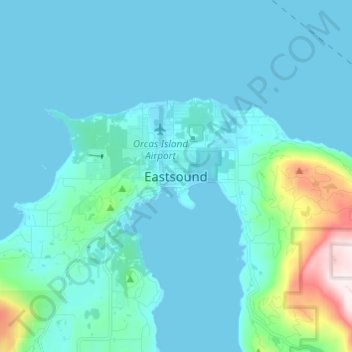
Name: Eastsound topographic map, elevation, terrain.
Average elevation: 74 m
Minimum elevation: -1 m
Maximum elevation: 642 m
Other topographic maps
Click on a map to view its topography, its elevation and its terrain.
San Juan Islands National Wildlife Refuge
United States > Washington > San Juan County
San Juan Islands National Wildlife Refuge, San Juan County, Washington, United States
Average elevation: 24 m
Eastsound
United States > Washington > San Juan County
Eastsound, San Juan County, Washington, United States, Orcas Island
Average elevation: 59 m
O'Neal Island
United States > Washington > San Juan County
O'Neal Island, San Juan County, Washington, United States
Average elevation: 18 m
Friday Harbor
United States > Washington > San Juan County
Friday Harbor, San Juan County, Washington, 98250, United States
Average elevation: 28 m
Ben Nevis
United States > Washington > San Juan County
Ben Nevis, San Juan County, Washington, 98286, United States
Average elevation: 49 m
Spencer Lake
United States > Washington > San Juan County > Thatcher
Spencer Lake, Thatcher, San Juan County, Washington, United States
Average elevation: 150 m