
Make a donation
Gear up for your next adventure:
As an Amazon Associate, this site earns from qualifying purchases at no extra cost to you.
Derby topographic map
Click on the map to display elevation.
Make a donation
Gear up for your next adventure:
As an Amazon Associate, this site earns from qualifying purchases at no extra cost to you.
Derby
According to the United States Census Bureau, the town has a total area of 5.4 square miles (8.7 km2), of which, 5.0 square miles (13 km2) is land and 0.4 square miles (1.0 km2) (7.41%) is water. The city is home to the 417 acres (0.652 sq mi) Osbornedale State Park. Derby is divided into two main sections by the Naugatuck River: East Derby and Derby Center (Birmingham). The center of Derby is approximately 66 miles (106 km) from New York City. The lowest elevation is 3 ft (1m) and the highest elevation is 466 ft (142m) above sea level.
Make a donation
Gear up for your next adventure:
As an Amazon Associate, this site earns from qualifying purchases at no extra cost to you.
About this map
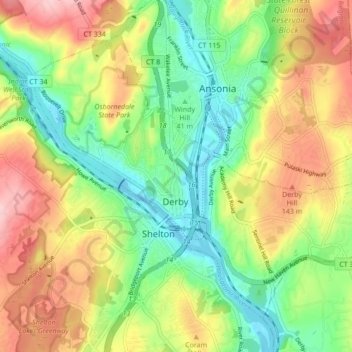
Name: Derby topographic map, elevation, terrain.
Location: Derby, New Haven County, Connecticut, United States (41.30100 -73.12465 41.35290 -73.03914)
Average elevation: 77 m
Minimum elevation: -5 m
Maximum elevation: 180 m
Make a donation
Gear up for your next adventure:
As an Amazon Associate, this site earns from qualifying purchases at no extra cost to you.