
Make a donation
Gear up for your next adventure:
As an Amazon Associate, this site earns from qualifying purchases at no extra cost to you.
Moon Lake topographic map
Click on the map to display elevation.
Make a donation
Gear up for your next adventure:
As an Amazon Associate, this site earns from qualifying purchases at no extra cost to you.
About this map
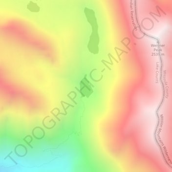
Name: Moon Lake topographic map, elevation, terrain.
Location: Moon Lake, Lake County, Montana, United States (47.42248 -113.90880 47.42622 -113.90562)
Average elevation: 2,006 m
Minimum elevation: 1,259 m
Maximum elevation: 2,537 m
Make a donation
Gear up for your next adventure:
As an Amazon Associate, this site earns from qualifying purchases at no extra cost to you.
Other topographic maps
Click on a map to view its topography, its elevation and its terrain.
Bozeman
United States > Montana > Gallatin County
Bozeman is located at an elevation of 4,820 feet (1,470 m). The Bridger Mountains are to the north-northeast, the Tobacco Root Mountains to the west-southwest, the Big Belt Mountains and Horseshoe Hills to the northwest, the Hyalite Peaks of the northern Gallatin Range to the south and the Spanish Peaks of the…
Average elevation: 1,495 m
Missoula
United States > Montana > Missoula County
Missoula is located at the western edge of Montana, approximately 45 miles (70 km) from the Idaho border. The city is at an elevation of 3,209 feet (978 m) above sea level, with nearby Mount Sentinel and Mount Jumbo steeply rising to 5,158 feet (1,572 m) and 4,768 feet (1,453 m), respectively. According to the…
Average elevation: 1,173 m
Chouteau County
The land is mostly rolling prairie, hence the high density of wheat farming. However, there is notable topography, namely some of Montana's forested island ranges. The Bear Paw Mountains rise in the northeast and the Little Rockies and the Highwood Ranges are in the southeast. Major rivers include the Teton…
Average elevation: 1,026 m
Glacier National Park
One of the most dramatic evidences of this overthrust is visible in the form of Chief Mountain, an isolated peak on the edge of the eastern boundary of the park rising 2,500 feet (800 m) above the Great Plains. There are six mountains in the park over 10,000 feet (3,000 m) in elevation, with Mount Cleveland at…
Average elevation: 1,594 m
Make a donation
Gear up for your next adventure:
As an Amazon Associate, this site earns from qualifying purchases at no extra cost to you.
Billings
United States > Montana > Yellowstone County
Two-thirds of the city is in the Yellowstone Valley and the South Hills area and one-third in the Heights-Lockwood area. The city is divided by the Rims, long cliffs, also called the Rimrocks. The Rims run to the north and east of the downtown core, separating it from the Heights to the north and Lockwood to…
Average elevation: 1,027 m
Helena
United States > Montana > Lewis and Clark County
Helena is located at 46°35′45″N 112°1′37″W / 46.59583°N 112.02694°W / 46.59583; -112.02694 (46.595805, −112.027031), at an altitude of 4,058 feet (1,237 m).
Average elevation: 1,301 m
Make a donation
Gear up for your next adventure:
As an Amazon Associate, this site earns from qualifying purchases at no extra cost to you.
Make a donation
Gear up for your next adventure:
As an Amazon Associate, this site earns from qualifying purchases at no extra cost to you.
Petroleum County
The county's eastern boundary is formed by the Musselshell River. According to the United States Census Bureau, the county has a total area of 1,674 square miles (4,340 km2), 1,655 square miles (4,290 km2) land and 19 square miles (49 km2) (1.1%) water. Its average elevation is 2,250–4,000 feet (690–1,220…
Average elevation: 916 m
Make a donation
Gear up for your next adventure:
As an Amazon Associate, this site earns from qualifying purchases at no extra cost to you.
Make a donation
Gear up for your next adventure:
As an Amazon Associate, this site earns from qualifying purchases at no extra cost to you.
Gallatin Gateway
United States > Montana > Gallatin County
Gallatin Gateway is a census-designated place (CDP) in Gallatin County, Montana, United States. As of the 2020 census, Gallatin Gateway had a population of 967. Elevation is 4,953 ft (1,510 m).
Average elevation: 1,519 m
Make a donation
Gear up for your next adventure:
As an Amazon Associate, this site earns from qualifying purchases at no extra cost to you.
Make a donation
Gear up for your next adventure:
As an Amazon Associate, this site earns from qualifying purchases at no extra cost to you.
Make a donation
Gear up for your next adventure:
As an Amazon Associate, this site earns from qualifying purchases at no extra cost to you.
Make a donation
Gear up for your next adventure:
As an Amazon Associate, this site earns from qualifying purchases at no extra cost to you.
Missoula
United States > Montana > Missoula County
Missoula is located at the western edge of Montana, approximately 45 miles (70 km) from the Idaho border. The city is at an elevation of 3,209 feet (978 m) above sea level, with nearby Mount Sentinel and Mount Jumbo steeply rising to 5,158 feet (1,572 m) and 4,768 feet (1,453 m), respectively. According to the…
Average elevation: 1,173 m
Make a donation
Gear up for your next adventure:
As an Amazon Associate, this site earns from qualifying purchases at no extra cost to you.
Big Sky
United States > Montana > Gallatin County
Big Sky is characterized by its dramatic and diverse topography, which forms part of the northern Rocky Mountains. The area features an elevation that ranges from around 5,500 feet in the valleys to more than 11,000 feet at its peaks, including the notable Lone Peak. This mountainous terrain is interspersed…
Average elevation: 2,435 m
Kalispell
United States > Montana > Flathead County
Kalispell is located at 48°11′52″N 114°18′58″W / 48.19778°N 114.31611°W / 48.19778; -114.31611 (48.197801, −114.316068), at an elevation of 2,956 feet (901 m).
Average elevation: 934 m
Bozeman
United States > Montana > Gallatin County
Bozeman is located at an elevation of 4,820 feet (1,470 m). The Bridger Mountains are to the north-northeast, the Tobacco Root Mountains to the west-southwest, the Big Belt Mountains and Horseshoe Hills to the northwest, the Hyalite Peaks of the northern Gallatin Range to the south and the Spanish Peaks of the…
Average elevation: 1,495 m
Make a donation
Gear up for your next adventure:
As an Amazon Associate, this site earns from qualifying purchases at no extra cost to you.
Make a donation
Gear up for your next adventure:
As an Amazon Associate, this site earns from qualifying purchases at no extra cost to you.
Make a donation
Gear up for your next adventure:
As an Amazon Associate, this site earns from qualifying purchases at no extra cost to you.
Make a donation
Gear up for your next adventure:
As an Amazon Associate, this site earns from qualifying purchases at no extra cost to you.
Make a donation
Gear up for your next adventure:
As an Amazon Associate, this site earns from qualifying purchases at no extra cost to you.
Make a donation
Gear up for your next adventure:
As an Amazon Associate, this site earns from qualifying purchases at no extra cost to you.
Make a donation
Gear up for your next adventure:
As an Amazon Associate, this site earns from qualifying purchases at no extra cost to you.
Bozeman
United States > Montana > Gallatin County
Bozeman is located at an elevation of 4,820 feet (1,470 m). The Bridger Mountains are to the north-northeast, the Tobacco Root Mountains to the west-southwest, the Big Belt Mountains and Horseshoe Hills to the northwest, the Hyalite Peaks of the northern Gallatin Range to the south and the Spanish Peaks of the…
Average elevation: 1,495 m
Butte
United States > Montana > Silver Bow County
Butte's South district, situated at a lower elevation below the hillside that comprises northern Butte, has historically been home to working-class neighborhoods. Gold mines originally populated south Butte before it was platted for the Union Pacific Railroad in 1881.
Average elevation: 1,909 m
Make a donation
Gear up for your next adventure:
As an Amazon Associate, this site earns from qualifying purchases at no extra cost to you.
Make a donation
Gear up for your next adventure:
As an Amazon Associate, this site earns from qualifying purchases at no extra cost to you.
Make a donation
Gear up for your next adventure:
As an Amazon Associate, this site earns from qualifying purchases at no extra cost to you.
Make a donation
Gear up for your next adventure:
As an Amazon Associate, this site earns from qualifying purchases at no extra cost to you.
Butte
United States > Montana > Silver Bow County
Butte's South district, at a lower elevation than the hillside that comprises northern Butte, has historically been home to working-class neighborhoods. Gold mines originally populated south Butte before it was platted for the Union Pacific Railroad in 1881.
Average elevation: 1,909 m
Kalispell
United States > Montana > Flathead County
Kalispell is located at 48°11′52″N 114°18′58″W / 48.19778°N 114.31611°W / 48.19778; -114.31611 (48.197801, −114.316068), at an elevation of 2,956 feet (901 m).
Average elevation: 934 m
Make a donation
Gear up for your next adventure:
As an Amazon Associate, this site earns from qualifying purchases at no extra cost to you.
Gates of the Mountains Wilderness
United States > Montana > Lewis and Clark County
Average elevation: 1,650 m
Make a donation
Gear up for your next adventure:
As an Amazon Associate, this site earns from qualifying purchases at no extra cost to you.
Make a donation
Gear up for your next adventure:
As an Amazon Associate, this site earns from qualifying purchases at no extra cost to you.
Make a donation
Gear up for your next adventure:
As an Amazon Associate, this site earns from qualifying purchases at no extra cost to you.