
Make a donation
Gear up for your next adventure:
As an Amazon Associate, this site earns from qualifying purchases at no extra cost to you.
Talkington Fork McElroy Creek topographic map
Click on the map to display elevation.
Make a donation
Gear up for your next adventure:
As an Amazon Associate, this site earns from qualifying purchases at no extra cost to you.
About this map
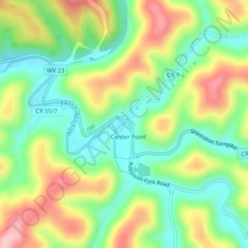
Name: Talkington Fork McElroy Creek topographic map, elevation, terrain.
Average elevation: 300 m
Minimum elevation: 230 m
Maximum elevation: 400 m
Make a donation
Gear up for your next adventure:
As an Amazon Associate, this site earns from qualifying purchases at no extra cost to you.
Other topographic maps
Click on a map to view its topography, its elevation and its terrain.
Center Point
United States > West Virginia > Center Point
Center Point is an unincorporated community in northeastern Doddridge County, West Virginia, USA. It lies along Route 23 northeast of the town of West Union, the county seat of Doddridge County. Its elevation is 791 feet (241 m).
Average elevation: 312 m