
Madison topographic map
Interactive map
Click on the map to display elevation.
About this map
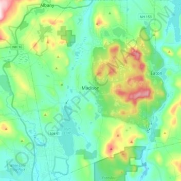
Name: Madison topographic map, elevation, terrain.
Location: Madison, Carroll County, New Hampshire, United States (43.83112 -71.21259 43.96365 -71.08117)
Average elevation: 216 m
Minimum elevation: 119 m
Maximum elevation: 502 m
Other topographic maps
Click on a map to view its topography, its elevation and its terrain.
Goe Hill
United States > New Hampshire > Madison
Goe Hill, Madison, Carroll County, New Hampshire, United States
Average elevation: 277 m