
Chatham Township topographic map
Interactive map
Click on the map to display elevation.
About this map
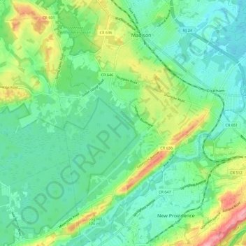
Name: Chatham Township topographic map, elevation, terrain.
Location: Chatham Township, Morris County, New Jersey, United States (40.68803 -74.45518 40.77163 -74.39069)
Average elevation: 86 m
Minimum elevation: 51 m
Maximum elevation: 169 m
Other topographic maps
Click on a map to view its topography, its elevation and its terrain.
Rolling Hill
United States > New Jersey > Morris County > Chatham Township
Rolling Hill, Chatham Township, Morris County, New Jersey, 07928, United States
Average elevation: 89 m
Floral Hill
United States > New Jersey > Morris County > Chatham Township > Floral Hill
Floral Hill, Chatham Township, Morris County, New Jersey, 07928, United States
Average elevation: 90 m