
McKinleyville topographic map
Interactive map
Click on the map to display elevation.
About this map
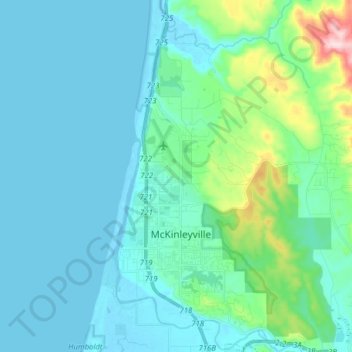
Name: McKinleyville topographic map, elevation, terrain.
Average elevation: 49 m
Minimum elevation: -5 m
Maximum elevation: 334 m
McKinleyville (formerly Minorsville) is a census-designated place (CDP) in Humboldt County, California, United States. McKinleyville is located 5.25 miles (8.4 km) north of Arcata, at an elevation of 141 feet (43 m). The population was 15,177 at the 2010 census, up from 13,599 at the 2000 census. This unincorporated community is the third largest community, after Eureka and Arcata, on the far North Coast and larger than five of seven cities in the county. It is also the location of the Arcata-Eureka Airport, the largest airport in Humboldt County and the region.