Geolocate

Loma Puerta Del Paramo topographic map

Interactive map

Click on the map to display elevation.

About this map

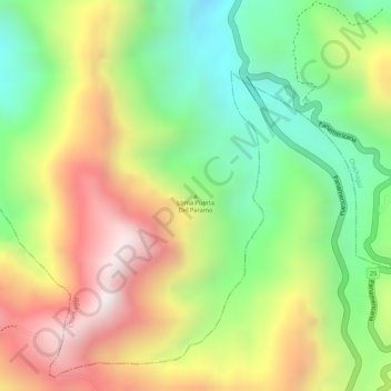
Name: Loma Puerta Del Paramo topographic map, elevation, terrain.

Location: Loma Puerta Del Paramo, Chachagüí, Centro, Nariño, Colombia (1.30711 -77.28237 1.30721 -77.28227)

Average elevation: 2,448 m

Minimum elevation: 2,098 m

Maximum elevation: 2,829 m

Other topographic maps

Click on a map to view its topography, its elevation and its terrain.

Samaniego

Colombia > Nariño

Average elevation: 1,837 m

Tumaco

Colombia > Nariño

Average elevation: 50 m

Cumbal

Colombia > Nariño

Average elevation: 3,092 m

Pasto

Colombia > Nariño > Pasto

Most of the city lies between 2,520 metres (8,270 ft) and 2,700 metres (8,900 ft) elevation above sea level, while some settlement exceeds 3,000 metres (9,800 ft) on the flanks of the Galeras Volcano, which stands at 4,276 metres (14,029 ft).

Average elevation: 2,676 m

Samaniego

Colombia > Nariño

Average elevation: 1,837 m

Pasto

Colombia > Nariño > Pasto

Most of the city lies between 2,520 metres (8,270 ft) and 2,700 metres (8,900 ft) elevation above sea level, while some settlement exceeds 3,000 metres (9,800 ft) on the flanks of the Galeras Volcano, which stands at 4,276 metres (14,029 ft).

Average elevation: 2,676 m

Guambuyaco

Colombia > Nariño

Average elevation: 1,021 m

El Peñol

Colombia > Nariño

Average elevation: 1,150 m

Mallama

Colombia > Nariño

Average elevation: 2,109 m

Pasto

Colombia > Nariño > Pasto > Pasto

Most of the city lies between 2,520 metres (8,270 ft) and 2,700 metres (8,900 ft) elevation above sea level, while some settlement exceeds 3,000 metres (9,800 ft) on the flanks of the Galeras Volcano, which stands at 4,276 metres (14,029 ft).

Average elevation: 2,668 m

La Sabana

Colombia > Nariño

Average elevation: 2,603 m

Parque Parana

Colombia > Nariño > Pasto

Average elevation: 2,553 m

Nariño

Colombia > Nariño

Average elevation: 2,506 m

Juanambú

Colombia > Nariño

Average elevation: 2,131 m

Túquerres

Colombia > Nariño

Average elevation: 2,735 m

Gualmatán

Colombia > Nariño

Average elevation: 3,055 m

Puerres

Colombia > Nariño

Average elevation: 2,524 m

Santacruz

Colombia > Nariño

Average elevation: 2,095 m

Santacruz

Colombia > Nariño > Santacruz

Average elevation: 2,095 m

Potosí

Colombia > Nariño > Potosí

Potosí features a rare climate for a city of its size, due to its extreme elevation at over 4000m. Semi-arid and with average temperatures in its warmest month sitting right on the 10 °C threshold, the city's climate straddles that of the subtropical highland climate (Cwc, according to the Köppen climate…

Average elevation: 2,713 m