
Gear up for your next adventure:
As an Amazon Associate, this site earns from qualifying purchases at no extra cost to you.
Make a donation
Szilvásvárad topographic map
Click on the map to display elevation.
Gear up for your next adventure:
As an Amazon Associate, this site earns from qualifying purchases at no extra cost to you.
Gear up for your next adventure:
As an Amazon Associate, this site earns from qualifying purchases at no extra cost to you.
Make a donation
About this map
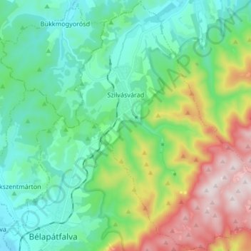
Name: Szilvásvárad topographic map, elevation, terrain.
Average elevation: 465 m
Minimum elevation: 271 m
Maximum elevation: 954 m
Gear up for your next adventure:
As an Amazon Associate, this site earns from qualifying purchases at no extra cost to you.
Make a donation
Other topographic maps
Click on a map to view its topography, its elevation and its terrain.
Kékes
Kékes Peak is the highest altitude region in Hungary, so it has the highest altitude weather station in the country. Although the mountain is still classified as a temperate humid continental climate (Dfb) according to the Köppen climate classification, it is very close to a subarctic climate (Dfc). Unlike…
Average elevation: 817 m
Gear up for your next adventure:
As an Amazon Associate, this site earns from qualifying purchases at no extra cost to you.
Make a donation