
Thank you for supporting this site ❤️
Make a donation
Make a donation
Gear up for your next adventure:
As an Amazon Associate, this site earns from qualifying purchases at no extra cost to you.
Uggelbo topographic map
Click on the map to display elevation.
Thank you for supporting this site ❤️
Make a donation
Make a donation
Gear up for your next adventure:
As an Amazon Associate, this site earns from qualifying purchases at no extra cost to you.
About this map
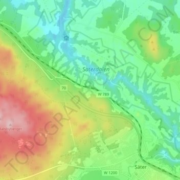
Name: Uggelbo topographic map, elevation, terrain.
Location: Uggelbo, Säter, Säters kommun, Dalecarlia, 783 22, Sweden (60.34408 15.70588 60.38408 15.74588)
Average elevation: 168 m
Minimum elevation: 96 m
Maximum elevation: 295 m
Thank you for supporting this site ❤️
Make a donation
Make a donation
Gear up for your next adventure:
As an Amazon Associate, this site earns from qualifying purchases at no extra cost to you.