
Kottakkal topographic map
Interactive map
Click on the map to display elevation.
About this map
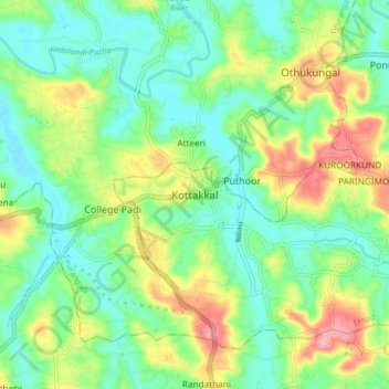
Name: Kottakkal topographic map, elevation, terrain.
Location: Kottakkal, Ernad, Malappuram, Kerala, 676503, India (10.96048 75.96476 11.04048 76.04476)
Average elevation: 45 m
Minimum elevation: 2 m
Maximum elevation: 126 m
Other topographic maps
Click on a map to view its topography, its elevation and its terrain.