
Make a donation
Gear up for your next adventure:
As an Amazon Associate, this site earns from qualifying purchases at no extra cost to you.
Nafpaktos topographic map
Click on the map to display elevation.
Make a donation
Gear up for your next adventure:
As an Amazon Associate, this site earns from qualifying purchases at no extra cost to you.
Nafpaktos
Today the population is about 19,768 people according to the 2011 census. Residential homes align with the Gulf of Corinth over a length of about 3 km (2 mi) and a width of about 1 km (0.6 mi). The port divides the beachfront in two parts. The Western part is called Psani, while the Eastern part Gribovo. Naupactus sits on a shoulder of a mountain range on the north while farmlands dominate the western part. It used to be on the GR-48/E65 linking Antirrio and Amfissa; now it is bypassed to the north at the elevation of 150 to 200 m (492 to 656 ft) above sea level. The bypass has contributed significantly in lowering the number of heavy trucks passing through the narrow streets of the town.
Make a donation
Gear up for your next adventure:
As an Amazon Associate, this site earns from qualifying purchases at no extra cost to you.
About this map
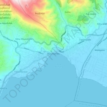
Name: Nafpaktos topographic map, elevation, terrain.
Average elevation: 130 m
Minimum elevation: -6 m
Maximum elevation: 967 m
Make a donation
Gear up for your next adventure:
As an Amazon Associate, this site earns from qualifying purchases at no extra cost to you.