
Can Gio District topographic map
Interactive map
Click on the map to display elevation.
About this map
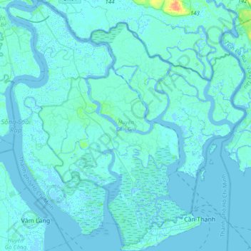
Name: Can Gio District topographic map, elevation, terrain.
Location: Can Gio District, Ho Chi Minh City, Vietnam (10.37617 106.73820 10.67519 107.02767)
Average elevation: 2 m
Minimum elevation: -5 m
Maximum elevation: 30 m
Other topographic maps
Click on a map to view its topography, its elevation and its terrain.
Ho Chi Minh City
Ho Chi Minh City is located in the south-eastern region of Vietnam, 1,760 km (1,090 mi) south of Hanoi. The average elevation is 5 m (16 ft) above sea level for the city center and 16 m (52 ft) for the suburb areas. It borders Tây Ninh Province and Bình Dương Province to the north, Đồng Nai Province and…
Average elevation: 6 m