
Make a donation
Gear up for your next adventure:
As an Amazon Associate, this site earns from qualifying purchases at no extra cost to you.
St Peter Port topographic map
Click on the map to display elevation.
Make a donation
Gear up for your next adventure:
As an Amazon Associate, this site earns from qualifying purchases at no extra cost to you.
About this map
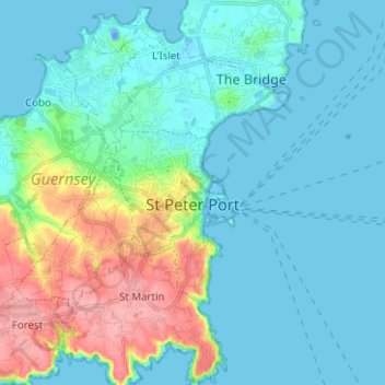
Name: St Peter Port topographic map, elevation, terrain.
Location: St Peter Port, Guernsey (49.43562 -2.56591 49.48289 -2.44092)
Average elevation: 23 m
Minimum elevation: -22 m
Maximum elevation: 105 m
Make a donation
Gear up for your next adventure:
As an Amazon Associate, this site earns from qualifying purchases at no extra cost to you.
Other topographic maps
Click on a map to view its topography, its elevation and its terrain.
abreuvoir of Saint Peter Port and Saint Martins
Guernsey > Guernsey > St Peter Port
Average elevation: 60 m
abreuvoir of Saint Peter Port and Saint Martins
Guernsey > Guernsey > St Peter Port
Average elevation: 60 m
Make a donation
Gear up for your next adventure:
As an Amazon Associate, this site earns from qualifying purchases at no extra cost to you.