
Kehra topographic map
Interactive map
Click on the map to display elevation.
About this map
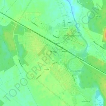
Name: Kehra topographic map, elevation, terrain.
Location: Kehra, Anija vald, Harju maakond, Estonia (59.32514 25.30936 59.34682 25.35706)
Average elevation: 51 m
Minimum elevation: 39 m
Maximum elevation: 65 m
Mustjõe station was first mentioned on the Estonian topographic map of 1935. An oxygen factory started operating there in 1937. The station ceased operating at some point and was reopened in 1978, when the railway was electrified. Lahinguvälja station was opened in 1939, near the place, where the battle of Kehra took place. The station was renamed to Vikipalu in 1957 and back to Lahinguvälja in 2009. Parila station was opened in 1973, when the railway was electrified.:261