
Lincolnshire topographic map
Interactive map
Click on the map to display elevation.
About this map
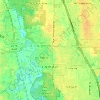
Name: Lincolnshire topographic map, elevation, terrain.
Location: Lincolnshire, Lake County, Illinois, 60069, United States (42.17527 -87.95108 42.22184 -87.88324)
Average elevation: 205 m
Minimum elevation: 191 m
Maximum elevation: 215 m
Other topographic maps
Click on a map to view its topography, its elevation and its terrain.
Lake Naomi
United States > Illinois > Lake County > Hawthorn Woods > White Birch Lakes
Average elevation: 261 m
Bishops Ridge
United States > Illinois > Lake County > Kildeer > Bishops Ridge
Average elevation: 253 m