
Gharb Seheil Village topographic map
Interactive map
Click on the map to display elevation.
About this map
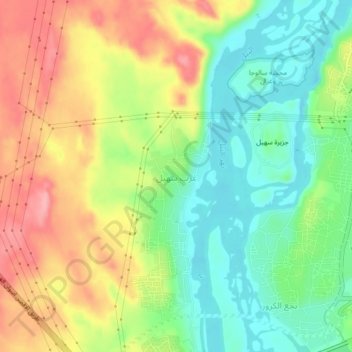
Name: Gharb Seheil Village topographic map, elevation, terrain.
Location: Gharb Seheil Village, Aswan, 81531, Egypt (24.03768 32.84019 24.07768 32.88019)
Average elevation: 132 m
Minimum elevation: 81 m
Maximum elevation: 197 m
Other topographic maps
Click on a map to view its topography, its elevation and its terrain.
Aswan Low Dam (Khazzan Aswan)
The Aswan Low Dam or Old Aswan Dam is a gravity masonry buttress dam on the Nile River in Aswan, Egypt. The dam was built by the British at the former first cataract of the Nile, and is located about 1000 km up-river and 690 km (direct distance) south-southeast of Cairo. When initially constructed between 1899…
Average elevation: 113 m