
Aundha (Nagnath) topographic map
Interactive map
Click on the map to display elevation.
About this map
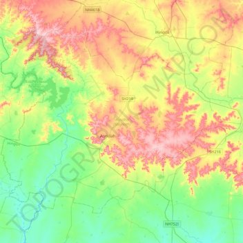
Name: Aundha (Nagnath) topographic map, elevation, terrain.
Location: Aundha (Nagnath), Hingoli, Maharashtra, 431705, India (19.41030 76.84971 19.71852 77.28491)
Average elevation: 445 m
Minimum elevation: 373 m
Maximum elevation: 553 m
Other topographic maps
Click on a map to view its topography, its elevation and its terrain.
Chimegaon
India > Maharashtra > Aundha (Nagnath)
Chimegaon, Aundha (Nagnath), Hingoli, Maharashtra, India
Average elevation: 404 m