
Make a donation
Gear up for your next adventure:
As an Amazon Associate, this site earns from qualifying purchases at no extra cost to you.
Ann Arbor topographic map
Click on the map to display elevation.
Make a donation
Gear up for your next adventure:
As an Amazon Associate, this site earns from qualifying purchases at no extra cost to you.
Ann Arbor
Ann Arbor is 11.2 miles (18.0 km) road miles west of Ypsilanti. Ann Arbor is also 42.1 miles (67.8 km) road miles west of Detroit. Ann Arbor Charter Township adjoins the city's north and east sides. Ann Arbor is situated on the Huron River in a productive agricultural and fruit-growing region. The landscape of Ann Arbor consists of hills and valleys, with the terrain becoming steeper near the Huron River. The elevation ranges from about 750 feet (230 m) along the Huron River to 1,015 feet (309 m) on the city's west side, near the intersection of Maple Road and Pauline Blvd. Generally, the west-central and northwestern parts of the city and U-M's North Campus are the highest parts of the city; the lowest parts are along the Huron River and in the southeast. Ann Arbor Municipal Airport, which is south of the city at 42°13.38′N 83°44.74′W / 42.22300°N 83.74567°W / 42.22300; -83.74567, has an elevation of 839 feet (256 m).
Make a donation
Gear up for your next adventure:
As an Amazon Associate, this site earns from qualifying purchases at no extra cost to you.
About this map
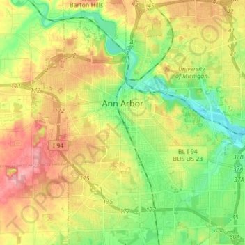
Name: Ann Arbor topographic map, elevation, terrain.
Location: Ann Arbor, Washtenaw County, Michigan, United States (42.22267 -83.79957 42.32389 -83.67581)
Average elevation: 268 m
Minimum elevation: 223 m
Maximum elevation: 326 m
Make a donation
Gear up for your next adventure:
As an Amazon Associate, this site earns from qualifying purchases at no extra cost to you.
Other topographic maps
Click on a map to view its topography, its elevation and its terrain.
Rawsonville
United States > Michigan > Washtenaw County > Ypsilanti Charter Township
Average elevation: 214 m
Frain Lake
United States > Michigan > Washtenaw County > Superior Charter Township
Average elevation: 259 m
Rawsonville
United States > Michigan > Washtenaw County > Ypsilanti Charter Township
Average elevation: 214 m
Make a donation
Gear up for your next adventure:
As an Amazon Associate, this site earns from qualifying purchases at no extra cost to you.
Rawsonville
United States > Michigan > Washtenaw County > Ypsilanti Charter Township
Average elevation: 214 m
Mooreville
United States > Michigan > Washtenaw County > York Charter Township
Average elevation: 222 m