
Jezzine topographic map
Interactive map
Click on the map to display elevation.
About this map
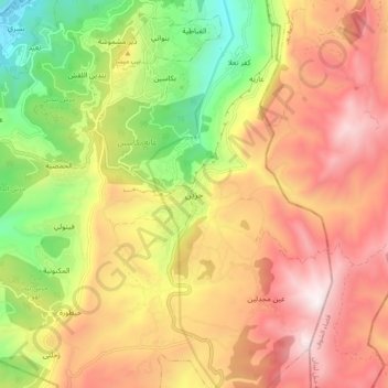
Name: Jezzine topographic map, elevation, terrain.
Location: Jezzine, Jezzine District, South Governorate, 1623, Lebanon (33.50393 35.54439 33.58393 35.62439)
Average elevation: 1,072 m
Minimum elevation: 393 m
Maximum elevation: 1,688 m
Jezzine (Arabic: جزين Jizzīn) is a town in Lebanon, located 22 km (14 mi) from Sidon and 40 km (25 mi) south of Beirut. It is the capital of Jezzine District. Surrounded by mountain peaks, pine forests (like the Bkassine Pine Forest), and at an average altitude of 950 m (3,117 ft), it is the main summer resort and tourist destination of South Lebanon. The town is also well-known in Lebanon for its production of handmade, traditional cutlery and daggers with decorative inlays, artisanal wine, and the shrine of Our Lady of the Waterfall.
Other topographic maps
Click on a map to view its topography, its elevation and its terrain.
Arzai
Arzai, Sidon District, South Governorate, Lebanon
Average elevation: 158 m
Jarmaq
Jarmaq, Jezzine District, South Governorate, 6728, Lebanon
Average elevation: 487 m
Sidon
Sidon, Saida Ed-Dekermane, Sidon, Sidon District, South Governorate, 1600, Lebanon
Average elevation: 230 m
As Sarafand
As Sarafand, Saida, Sidon District, South Governorate, Lebanon
Average elevation: 71 m
Ghaziyeh
Ghaziyeh, Saida, Sidon District, South Governorate, 1600, Lebanon
Average elevation: 89 m
Jbal El Botm
Jbal El Botm, Tyre District, South Governorate, Lebanon
Average elevation: 383 m
Al Aqbieh
Al Aqbieh, Saida, Sidon District, South Governorate, Lebanon
Average elevation: 56 m
Tyre
Tyre, Tyre District, South Governorate, 1601, Lebanon
Average elevation: 5 m
Darb Es Sim
Lebanon > South Governorate > Darb Es Sim
Darb Es Sim, Sidon District, South Governorate, 1600, Lebanon
Average elevation: 82 m
Qana
Lebanon > South Governorate > Qana
Qana, Tyre District, South Governorate, Lebanon
Average elevation: 291 m
Bisri
Lebanon > South Governorate > Bisri
Bisri, Jezzine District, South Governorate, 6662, Lebanon
Average elevation: 631 m
Babliyeh
Lebanon > South Governorate > Sidon > Babliyeh
Babliyeh, Sidon, Sidon District, South Governorate, 1600, Lebanon
Average elevation: 215 m
Jlall Aairam
Lebanon > South Governorate > Saida > Jlall Aairam
Jlall Aairam, Saida, Sidon District, South Governorate, 1600, Lebanon
Average elevation: 18 m
Ain Baal
Ain Baal, Aain Baal, Tyre District, South Governorate, Lebanon
Average elevation: 150 m