
Llanbedr topographic map
Interactive map
Click on the map to display elevation.
About this map
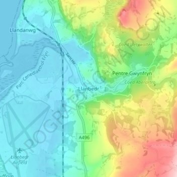
Name: Llanbedr topographic map, elevation, terrain.
Location: Llanbedr, Gwynedd, Wales, LL45 2LD, United Kingdom (52.80038 -4.11990 52.84038 -4.07990)
Average elevation: 56 m
Minimum elevation: -1 m
Maximum elevation: 197 m
Other topographic maps
Click on a map to view its topography, its elevation and its terrain.
Llanbedr
United Kingdom > Wales > Llanbedr
Llanbedr, Powys, Wales, NP8 1SQ, United Kingdom
Average elevation: 283 m