
Tabriz topographic map
Interactive map
Click on the map to display elevation.
About this map
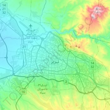
Name: Tabriz topographic map, elevation, terrain.
Average elevation: 1,538 m
Minimum elevation: 1,327 m
Maximum elevation: 2,360 m
Tabriz (Persian: تبریز [tæbˈɾiːz] (listen); Azerbaijani: تبریز) is a city in northwestern Iran, serving as the capital of East Azerbaijan Province. It is the sixth-most-populous city in Iran. In the Quru River valley in Iran's historic Azerbaijan region between long ridges of volcanic cones in the Sahand and Eynali mountains, Tabriz's elevation ranges between 1,350 and 1,600 m (4,430 and 5,250 ft) above sea level. The valley opens up into a plain that gently slopes down to the eastern shores of Lake Urmia, 60 km (37 mi) to the west. With cold winters and temperate summers, Tabriz is considered a summer resort. It was named World Carpet Weaving City by the World Crafts Council in October 2015 and Exemplary Tourist City of 2018 by the Organisation of Islamic Cooperation.
Other topographic maps
Click on a map to view its topography, its elevation and its terrain.
Safire omid town
Iran > East Azerbaijan Province > Tabriz County > Tabriz
Safire omid town, Tabriz, بخش مرکزی شهرستان تبریز, Tabriz County, East Azerbaijan Province, Iran
Average elevation: 1,426 m
Ughli
Iran > East Azerbaijan Province > Tabriz County > دهستان آجی چای
Ughli, دهستان آجی چای, بخش مرکزی شهرستان تبریز, Tabriz County, East Azerbaijan Province, 51896-13131, Iran
Average elevation: 1,457 m
Iskandar
Iran > East Azerbaijan Province > Tabriz County
Iskandar, بخش مرکزی شهرستان تبریز, Tabriz County, East Azerbaijan Province, Iran
Average elevation: 1,806 m
دهستان میدان چای
Iran > East Azerbaijan Province > Tabriz County > دهستان میدان چای
دهستان میدان چای, بخش مرکزی شهرستان تبریز, Tabriz County, East Azerbaijan Province, +9841, Iran
Average elevation: 2,075 m