
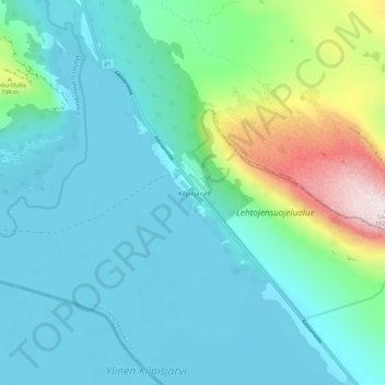
Kilpisjärvi topographic map
Interactive map
Click on the map to display elevation.
About this map
Name: Kilpisjärvi topographic map, elevation, terrain.
Average elevation: 576 m
Minimum elevation: 469 m
Maximum elevation: 1,027 m
Although Kilpisjärvi is one of the largest villages in Enontekiö, it is still quite small. In 2000 its population was recorded as 114. Like most Sami villages, Kilpisjärvi is built mainly around one major road, Käsivarrentie, or the "Arm Road" and Neljäntuulentie, or the "Four Winds' Road" — also known as E8. Near Kilpisjärvi is the highest point of Finnish road network, at an elevation of 565.8 m.
Other topographic maps
Click on a map to view its topography, its elevation and its terrain.
Enontekiö
Finland > Northern Finland > Enontekiö
Enontekiö, Tunturi-Lapin seutukunta, Lapland, Mainland Finland, Finland
Average elevation: 405 m