
Thiruvalla topographic map
Interactive map
Click on the map to display elevation.
Thiruvalla
Thiruvalla lies at an altitude of 9 meters above sea level on the basin of the Pamba and Manimala rivers. Thiruvalla is dotted with several natural canal streams (called "thodu" in Malayalam) like Chanthathodu, Manippuzha, Mullelithodu, and several others. The city area has riverine alluvial soil, and eastern parts have a laterite loam kind of soil classified under "Southern Midlands" agro-ecological zone, while the western suburbs like Niranam have a more sandy type of soil that resembles beaches. (Kuttanad agro-ecological zone)[7] The reason for this is believed to be the older status of Niranam as a port, before reclamation of Kuttanad from sea occurred. The Upper Kuttanad region in Thiruvalla has the "Karappadam" type of soil, which is clay loam in texture, has high organic matter, and is situated in areas about 1–2 m above sea level.[7]
About this map
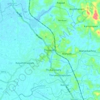
Name: Thiruvalla topographic map, elevation, terrain.
Location: Thiruvalla, Pathanamthitta, Kerala, 689111, India (9.34674 76.53627 9.42674 76.61627)
Average elevation: 10 m
Minimum elevation: -1 m
Maximum elevation: 74 m
Other topographic maps
Click on a map to view its topography, its elevation and its terrain.