
Kon Tum City topographic map
Interactive map
Click on the map to display elevation.
About this map
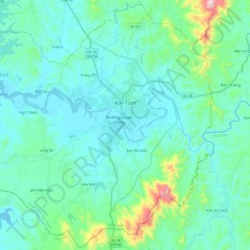
Name: Kon Tum City topographic map, elevation, terrain.
Location: Kon Tum City, Kon Tum province, Vietnam (14.22822 107.85000 14.45365 108.08841)
Average elevation: 609 m
Minimum elevation: 506 m
Maximum elevation: 1,191 m
Other topographic maps
Click on a map to view its topography, its elevation and its terrain.
Làng Sá
Vietnam > Kon Tum province > Kon Tum City > Làng Sá
Làng Sá, Kon Tum City, Kon Tum province, 600000, Vietnam
Average elevation: 592 m