
Ouarzazate topographic map
Interactive map
Click on the map to display elevation.
About this map
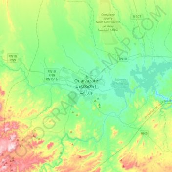
Name: Ouarzazate topographic map, elevation, terrain.
Average elevation: 1,247 m
Minimum elevation: 1,052 m
Maximum elevation: 1,753 m
Ouarzazate (Arabic: ورزازات Warzāzāt, Kabyle: ⵡⴰⵔ ⵣⴰⵣⴰⵝ Warzazat) nicknamed The door of the desert, is a city and capital of Ouarzazate Province in Drâa-Tafilalet region of south-central Morocco. Ouarzazate is at an elevation of 1,160 metres (3,810 ft) in the middle of a bare plateau south of the High Atlas Mountains. To the south of the town is the desert.