
Belgorod topographic map
Interactive map
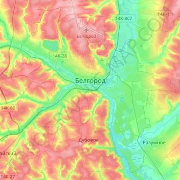
Click on the map to display elevation.
About this map
Name: Belgorod topographic map, elevation, terrain.
Average elevation: 163 m
Minimum elevation: 107 m
Maximum elevation: 227 m
There were several attacks and incidents reported in Belgorod following the start of the Russian invasion of Ukraine in 2022, during which Belgorod was an important logistics centre for Russian armies. Notably, on 1 April 2022 two Ukrainian Mi-24 performed a night raid and set fire to a fuel depot in Belgorod, in a low-altitude airstrike. On 20 April 2023, a Russian Su-34 fighter jet accidentally dropped a bomb on the city, leaving a crater 20 metres (66 ft) across and injuring two people. On 22 April, more than 3,000 people were evacuated from their homes after an undetonated explosive was found; it was not known if the second bomb had come from the same aircraft.
Other topographic maps
Click on a map to view its topography, its elevation and its terrain.
Shchetinovka
Russia > Belgorod Oblast > Belgorodsky District
Shchetinovka, Щетиновское сельское поселение, Belgorodsky District, Belgorod Oblast, Central Federal District, Russia
Average elevation: 183 m