
Butterworth topographic map
Interactive map
Click on the map to display elevation.
About this map
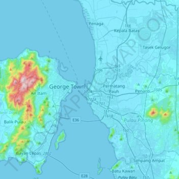
Name: Butterworth topographic map, elevation, terrain.
Average elevation: 39 m
Minimum elevation: -5 m
Maximum elevation: 798 m
Other topographic maps
Click on a map to view its topography, its elevation and its terrain.
Kampung Teluk
Malaysia > Penang > Butterworth
Kampung Teluk, Butterworth, North Seberang Perai District, Seberang Perai, Penang, 13800, Malaysia
Average elevation: 4 m
Pengkalan Macang
Malaysia > Penang > Butterworth > Pengkalan Macang
Pengkalan Macang, Butterworth, North Seberang Perai District, Seberang Perai, Penang, 13800, Malaysia
Average elevation: 4 m