
Clermont-Ferrand topographic map
Interactive map
Click on the map to display elevation.
Clermont-Ferrand
A racing circuit, the Charade Circuit, close to the city, using closed-off public roads held the French Grand Prix in 1965, 1969, 1970 and 1972. It was a daunting circuit, with such harsh elevation changes that caused some drivers to be ill as they drove. Winners included Jim Clark, Jackie Stewart (twice), and Jochen Rindt.
About this map
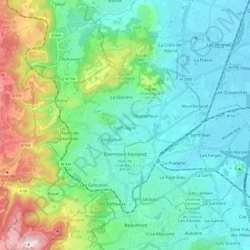
Name: Clermont-Ferrand topographic map, elevation, terrain.
Average elevation: 470 m
Minimum elevation: 326 m
Maximum elevation: 899 m
Other topographic maps
Click on a map to view its topography, its elevation and its terrain.
Beaune-le-Chaud
France > Auvergne-Rhône-Alpes > Puy-de-Dôme > Saint-Genès-Champanelle
Average elevation: 941 m
Les Gicons
France > Auvergne-Rhône-Alpes > Puy-de-Dôme > Montaigut-en-Combraille
Average elevation: 608 m
La Live
France > Auvergne-Rhône-Alpes > Puy-de-Dôme > Glaine-Montaigut > Glaine
Average elevation: 363 m
Soulace
France > Auvergne-Rhône-Alpes > Puy-de-Dôme > Marsac-en-Livradois > Flaittes
Average elevation: 621 m
Mareuge
France > Auvergne-Rhône-Alpes > Puy-de-Dôme > Le Vernet-Sainte-Marguerite
Average elevation: 1,062 m
Les Chaux
France > Auvergne-Rhône-Alpes > Puy-de-Dôme > Saint-Amant-Roche-Savine > Les Chaux
Average elevation: 901 m
La Cottas
France > Auvergne-Rhône-Alpes > Puy-de-Dôme > Champétières > Chatelet
Average elevation: 779 m
Andan
France > Auvergne-Rhône-Alpes > Puy-de-Dôme > Saint-Jacques-d'Ambur > Andan
Average elevation: 624 m