
Astana topographic map
Interactive map
Click on the map to display elevation.
About this map
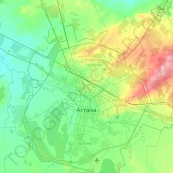
Name: Astana topographic map, elevation, terrain.
Location: Astana, 010000, Kazakhstan (50.85761 71.21797 51.35111 71.78519)
Average elevation: 361 m
Minimum elevation: 330 m
Maximum elevation: 435 m
Astana is located in central Kazakhstan on the Ishim River in a very flat, semi-arid steppe region which covers most of the country's territory. It is at 51° 10' north latitude and 71° 26' east longitude. The city encompasses 722.0 square kilometres (278.8 sq mi). The elevation of Astana is 347 metres (1,138 ft) above sea level. Astana is in a spacious steppe landscape, in the transitional area between the north of Kazakhstan and the extremely thinly settled national centre, because of the Ishim River. The older boroughs lie north of the river, whilst the new boroughs are located south of the Ishim.