
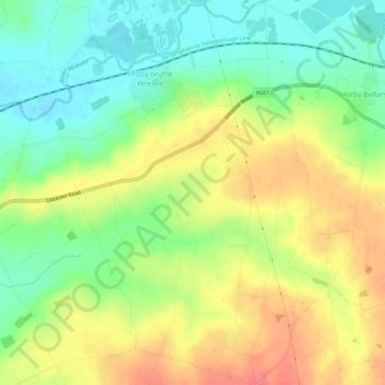
Frisby on the Wreake topographic map
Interactive map
Click on the map to display elevation.
About this map
Name: Frisby on the Wreake topographic map, elevation, terrain.
Average elevation: 90 m
Minimum elevation: 60 m
Maximum elevation: 125 m
Other topographic maps
Click on a map to view its topography, its elevation and its terrain.
Belvoir
United Kingdom > England > Melton
Belvoir, Melton, Leicestershire, East Midlands, England, United Kingdom
Average elevation: 92 m
Burrough Hill
United Kingdom > England > Melton
Burrough Hill, Melton, Leicestershire, East Midlands, England, LE14 2QZ, United Kingdom
Average elevation: 162 m
Asfordby
United Kingdom > England > Melton
Asfordby, Melton, Leicestershire, East Midlands, England, United Kingdom
Average elevation: 95 m
Burton and Dalby
United Kingdom > England > Melton
Burton and Dalby, Melton, Leicestershire, East Midlands, England, United Kingdom
Average elevation: 112 m
Freeby
United Kingdom > England > Melton
Freeby, Melton, Leicestershire, East Midlands, England, United Kingdom
Average elevation: 103 m
Buckminster
United Kingdom > England > Melton
Buckminster, Melton, Leicestershire, East Midlands, England, United Kingdom
Average elevation: 135 m