
Ulič topographic map
Interactive map
Click on the map to display elevation.
About this map
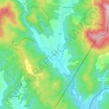
Name: Ulič topographic map, elevation, terrain.
Average elevation: 389 m
Minimum elevation: 213 m
Maximum elevation: 811 m
The municipality lies at an altitude of 245 metres and covers an area of 25.147 km². According to the 2013 census it had a population of about 916 inhabitants.
Other topographic maps
Click on a map to view its topography, its elevation and its terrain.
Snina
Slovakia > Region of Prešov > District of Snina
Snina, District of Snina, Region of Prešov, Eastern Slovakia, 069 01, Slovakia
Average elevation: 368 m