
Arches National Park topographic map
Interactive map
Click on the map to display elevation.
About this map
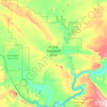
Name: Arches National Park topographic map, elevation, terrain.
Location: Arches National Park, Grand County, Utah, United States (38.60474 -109.71320 38.84693 -109.47771)
Average elevation: 1,476 m
Minimum elevation: 1,206 m
Maximum elevation: 1,995 m
The park consists of 310.31 square kilometres (76,680 acres; 119.81 sq mi; 31,031 ha) of high desert located on the Colorado Plateau. The highest elevation in the park is 5,653 feet (1,723 m) at Elephant Butte, and the lowest elevation is 4,085 feet (1,245 m) at the visitor center. The park receives an average of less than 10 inches (250 mm) of rain annually.
Other topographic maps
Click on a map to view its topography, its elevation and its terrain.
Moab
United States > Utah > Grand County
Moab, Grand County, Utah, 84532, United States
Average elevation: 1,357 m
Manns Peak
United States > Utah > Grand County
Manns Peak, Grand County, Utah, United States
Average elevation: 3,427 m
Castle Valley
United States > Utah > Grand County
Castle Valley, Grand County, Utah, United States
Average elevation: 1,610 m
Castleton Tower
United States > Utah > Grand County
Castleton Tower, Grand County, Utah, United States
Average elevation: 1,549 m