
Myrtle Beach topographic map
Interactive map
Click on the map to display elevation.
About this map
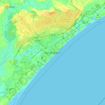
Name: Myrtle Beach topographic map, elevation, terrain.
Location: Myrtle Beach, Horry County, South Carolina, United States (33.53565 -79.05004 33.85565 -78.73004)
Average elevation: 4 m
Minimum elevation: -5 m
Maximum elevation: 17 m
Other topographic maps
Click on a map to view its topography, its elevation and its terrain.
Back Gate
United States > South Carolina > Horry County > Myrtle Beach
Back Gate, Myrtle Beach, Horry County, South Carolina, 29577, United States
Average elevation: 4 m
Market Common District
United States > South Carolina > Horry County > Myrtle Beach
Market Common District, Myrtle Beach, Horry County, South Carolina, 29577, United States
Average elevation: 5 m