
Caldmore topographic map
Interactive map
Click on the map to display elevation.
About this map
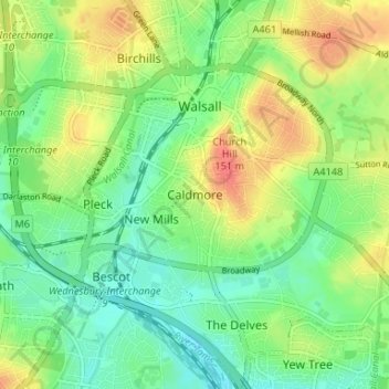
Name: Caldmore topographic map, elevation, terrain.
Average elevation: 131 m
Minimum elevation: 110 m
Maximum elevation: 160 m
Other topographic maps
Click on a map to view its topography, its elevation and its terrain.
Pheasey
United Kingdom > England > Walsall
Pheasey, Walsall, West Midlands Combined Authority, England, B43 7LB, United Kingdom
Average elevation: 155 m
Barr Beacon
United Kingdom > England > Walsall > Pheasey
Barr Beacon, Pheasey, Walsall, West Midlands Combined Authority, England, United Kingdom
Average elevation: 177 m
Great Barr
United Kingdom > England > Walsall
Great Barr, Walsall, West Midlands Combined Authority, England, B43 7BB, United Kingdom
Average elevation: 152 m
Blakenall Heath
United Kingdom > England > Walsall > Blakenall Heath
Blakenall Heath, Walsall, West Midlands Combined Authority, West Midlands, England, WS3 1HL, United Kingdom
Average elevation: 146 m
Barr Beacon
United Kingdom > England > Walsall
Barr Beacon, Walsall, West Midlands Combined Authority, West Midlands, England, WS9 0QW, United Kingdom
Average elevation: 176 m
Barr Beacon
United Kingdom > England > Walsall > Barr Beacon
Barr Beacon, Walsall, West Midlands Combined Authority, West Midlands, England, WS9 0QW, United Kingdom
Average elevation: 166 m